Back on the road again. Well …. Not exactly on the road. But camping, anyway. Over at Sesquicentennial State Park just outside Columbia, South Carolina. Yes, yes, I know. I’ve been here dozens of times. Each time, though, I learn something different about this remarkable 1,600-acre property.
The advantage this trip is that it’s only about three miles from the house. Just across Two Notch Road (That’s U.S. Route One for you non-South Carolinians). Good place to get back into the swing of RV camping after being confined to quarters for a while.
 Now, Sesqui is smack dab in the middle of South Carolina’s Sandhills environment, with its fascinating vegetation and animal life. A great place to visit and to camp. But the Sandhills environment presents special challenges for park managers and their maintenance crews.
Imagine trying to maintain unpaved roads and campsites here. Well, somehow they manage. I took the photos above this morning. Yesterday it rained cats and dogs here. A real frog-strangler. Not every campsite is this level and smooth. But most are. Remarkable! Crews were already out early this morning, clearing drains, removing all signs of the storm.
 I’ll stop bragging on Sesquicentennial now, but have to encourage you to come by. If you haven’t been here in the past seven years or so, do come back to have a look around. I think you’ll be pleased with all the changes.
 Camp if you’re able. RV or Tent. If you can’t camp, come by to hike the trails, use the dog park, or just walk around. Stop by the office to see the exhibits that Park Naturalist Stacy has prepared. Sign up for one of her programs if you have the time. You’ll learn a lot.
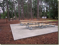
 Oh, a couple of important developments. I’ve got to find out more about these. But have a look at the new picnic tables above. I think there are three new areas like this. Notice the extended section of the nearest table. Ideal for folks using wheeled vehicles. And that new concrete pad is solid as a rock. Somebody must’ve won a grant! If you’re planning an event and would like to use one of these picnic areas, be sure to make a reservation. They’re being heavily used already.
 You long-time readers may recall me moaning about plant life taking over Sesqui’s Lake. Discouraging my ElderKayaking. Well, look at this! The whole lake is like this now. Aquatic plants are restricted to just one small section.
And the fish are back. Now, we all know that you can’t rely on Park personnel to describe how good the fishing is in their Park’s lakes. These folks assure me, though, there are plenty now here at Sesqui. Some of them real lunkers.
So there you have it. Sesquicentennial State Park. A great place to RV or tent camp; a great place to visit. Come on by the next time your travels take you near Columbia, South Carolina.


